 This community based project was launched in March 2005 to survey and record all the boundary stones on the fourteen areas of Common Land that make up Blisland Commons.
The project was funded by the Local Heritage Initiative, a national grant scheme to help local groups to investigate, explain and care for their landscape, landmarks, traditions and culture. The LHI is run by the Countryside Agency and funded by the Heritage Lottery Fund and the Nationwide Building Society
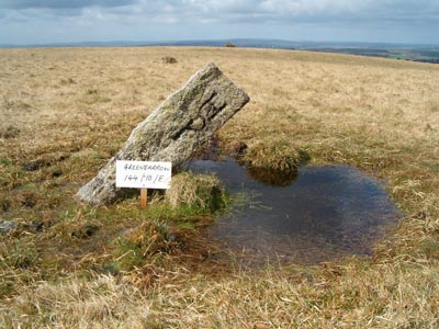
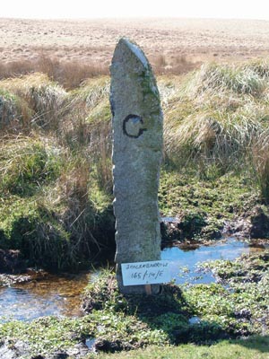
The majority of these boundary stones are post-medieval and are usually inscribed with letters or symbols denoting the name of each landowner or the manorial estate. Although all the areas of Common Land are part of the Blisland Commons, geographically they cover parts of four different parishes: Blisland, St Breward, Temple and Cardinham. These landscape features have never been fully recorded, or set in context with the land they bound, some have fallen over, while others have entirely disappeared
The aims and objectives of the project were:
- Produce a community-based project.
- Survey and record all the boundary stones on the Blisland Commons.
- Re-instate boundary stones that have fallen over.
- Provide replacement boundary stones where the original ones have become lost.
- Name each parcel of Common Land by inscribing a suitable boulder within each area.
- Actively encourage community involvement.
- Promote the project through local schools and educational facilities.
- Develop a Creative Arts based project with Blisland School.
- Provide a local exhibition or display at Blisland to procure information for the final report.
- Finally, produce a report recording the history of the various groups of boundary stones, their context in the landscape, and the areas of Common Land that they bound.
- The report will also include the results of the survey, with photographs of the boundary stones and the practical projects undertaken.
- The report will be published within a web site on the World Wide Web and a limited number of hard-copies will be produced for local libraries, the Commons Association and other interested parties.
Impact of the project:
- The project will highlight the significance of these landscape features to the wider community.
- The project will set the boundary stones in context, and bring together a range of local people to help preserve part of Bodmin Moor's heritage.
- The publication of the project report on the World Wide Web will provide public awareness not only locally and nationally but also potentially to everyone.
- The project report will also provide a record that will aid the future management of the boundary stones on Bodmin Moor.
- The project report, produced as a hard copy and deposited in local libraries, will also become a valuable resource for future research.
The project was divided up into a number of key stages that include:
- Desk-based assessment (preliminary research).
- Field-based and community survey of all the boundary stones on each area of Common Land.
- Collating the results of the survey.
- Further documentary research and analysis.
- Clearance of vegetation from around certain boundary stones.
- Erecting fallen boundary stones.
- Procuring and erecting replacement boundary stones.
- Carving of letters / symbols on replacement boundary stones.
- Carving the names of individual commons on suitable granite boulders in each area of Common Land.
- Promoting the project through a Creative Arts based project with Blisland School.
- Production of a small exhibition or display prior to producing the final report.
- Producing a web-site on the World Wide Web.
- Production of the final report for publication on the web-site, with a limited number of hard-copies.
- Revitalising tradition and heritage through performing the 'Beating of the Bounds'.